EPZR Żar Airport Aerial Photos & General Improvements v1.0
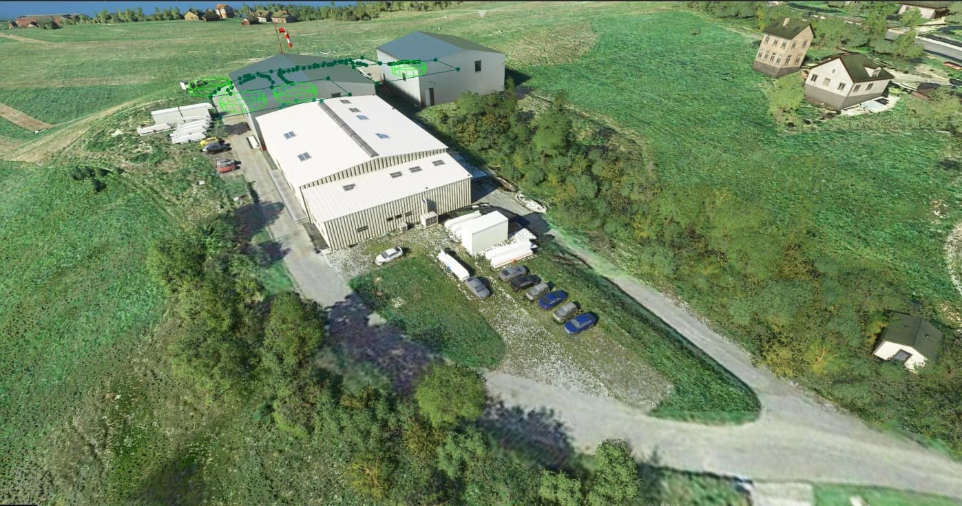
This mod adds various improvements and high-resolution zoom level 19 aerial photos for EPZR Żar airport in southern Poland that was really badly represented in the base sim.
About the airport:
The airport is nested on a mountain called Żar, it has 2 grass runways (04/22, 08/26), with a tower frequency of 122.805. Due to the surrounding mountains you can etiher enter the valley from the north, or south, also you don’t execute a traffic pattern. You can land at the airport only on runway 04 (main) or 08 (secondary) due to the runway slope, you takeoff from the opposite runways. There is no go-around procedure. It’s basically like a Polish version of Courchevel airport.
Contents of the mod:
Added high-resolution zoom level 19 aerial photos of the area taken from Google Maps;
Added trees where they were missing;
Changed tree type to deciduous;
Changed default hangars to generic hangar buildings that better fit the apron;
Added a tower frequency of 122.805;
Added apron ground materials;
Added static objects (gliders, glider trailers, cars, containers) to the apron and to the vicinity of the airport;
Added 3 parking spots and 1 refueling spot;
Added a windsock (currently it’s in the wrong place, in real life it’s on top of a hangar, however if it’s placed there in the sim it sometimes goes inside the hangar);
Added a radio tower at the top of Żar mountain;
Changed the airport type to a star airport.
Note:
The area in the valley still has really bad photos with tons of clouds. I plan on making additional mods that improve them, but because of the size of those photos, they will be released as a seperate addon in the future.
Additional info about the approach
1. Night flights PPR.
2. Aerodrome circuit is not carried out.
3. Landing shall be carried out on RWY 05 (RWY 08 auxiliary).
4. Caution: Due to landing up-hill, executing go-around manoeuvre from landing flare is NOT POSSIBLE.
5. Bidirectional radio communication within ATZ mandatory.
6. Airplanes:
a. arriving from the north and west shall proceed to Międzybrodzie Bialskie, then along river valley and next with left turn joining final,
b. arriving from the south, shall proceed to Tresna, then along river valley and next with right turn joining final.
7. Gliders approaching to land:
a. before proceeding final gliders shall descend in circling zone at south-eastern edge of the airfield (Soła river valley),
b. before proceeding final gliders shall descend on heading 230° along north-western edge of airfield and perform 180° left turn on final (along Soła river valley),
c. before proceeding final gliders shall descend on heading 230° along north-eastern edge of airfield and perform 180° right turn on final (along Soła river valley).
8. Glider landing manoeuvre is dependant on direction and wind velocity.
9. Glider take-offs:
a. winch launching on headings 050° i 230°,
b. bungee launching from top of Mt. Żar on headings 000° i 270°.
10. Maintain high vigilance – intensive paragliding activity.
11. Caution: During autumn, winter-spring seasons frequent foehn (“halny”) from the south up to 10-14 m/s.
1) SLOP OF RWY 05/23 6,5%
2) SLOP OF RWY 08/26 5,3%.
Known issues:
Runway 08/26 is visible on the ground, but isn’t displayed in the airport info. This is because in order to add the runway info you have to add a runway object itself, and that screws up the slope of the runway;
Sometimes a car can drive through a portion of the apron. This is because a portion of the apron is detected as road. In the current version of the SDK this can’t be fixed;



![[ZPJM] Lancang Jingmai Airport v1.0](https://www.allflightmods.com/wp-content/uploads/2021/09/ZPJM-Lancang-Jingmai-Airport-v1.0-520x245.png)
