Quatam River airport and Moh Creek Airport v1.0
Quatam River airport and Moh Creek Airport , Canada
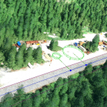
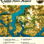
Quatam River Airport is a small airport in the mountains of British Columbia, Canada. The airport is located in a series of fjords and arms so although ocean water is just off the runway it is a long journey to the open sea. The airport is just meters from the Quatam River which leads up a long valley and into the tall mountains. The airport is a hub for forest workers who are clearing out the forest up and down the valley sides. The airport has been there for more than 35 years serving many purposes.
Airport Name Quatam River Airport
ICAO Code CA-0302
Location GPS 50.384796, -124.942464
Elevation 50 ft AMSL
Airport Name Moh Creek Airport
ICAO Code CA-0240
Location GPS 50.524996, -125.052933
Elevation 180 ft AMSL
powel watchtower (GPS 50.454424, -124.999585)
deep valley climbing camp (GPS 50.411752, -124.812346)
medical unit helipad (GPS 50.392790, -124.877730)
note:
due to MSFS airport name limitation to 5 letters/digits
airports have been renamed to C0302 and C0240 so they will appear on MSFS map as C0302 and C0240
v1.0
1..creation of Quatam River airport and Moh Creek Airport
2..creation of powel watchtower ,deep valley climbing camp, medical unit helipad
3..buildings and various objects (windsock, cars…)
4..remove water on shore west of runway
GPS Coordinates: 50.384796, -124.942464


