NavLog Genius! v1.0
This is a LibreOffice Calc file in which you can setup a flight plan, and start to auto-complete the corresponding navlog.
The file is provide with a sample flight plan and navigation log, for a trip in France between LFQW and LFGB, with a Cessna C172SP.
The file consists of 2 sheets :
Sheet 1 : FLIGHT PLAN
This is where you plan your flight by defining a departure and arrival airport, as well as the various waypoints (max. 6). Only cells with a light yellow background color can / should be filled.
Information you have to provide is :
Departure Airport (B5)
QFU (E5)
QNH (F5)
Altitude (G5)
COM frequence (M5)
Arrival Airport (B20)
QFU (E20)
QNH (F20)
Altitude (G20)
COM frequence (M20)
Turning points
Identification (B6-B18)
Type (D6-D18) : list of values : NDB ; VOR ; VOR/DME ; VOR/LOC ; WAYPNT ; VFR
Course (H6-H18) : this is the theoretical course to follow to connect this point
Route (I6-I18) : this is the actual heading to follow to connect this point, taking into account mainly the weather conditions and the drift due to the wind (*)
Distance (J6-J18) : this is the distance with the previous point (nautic miles)
Time (K6-K18) : this is the time to fly from the previous point (minutes:seconds)
ADF (L6-L18) : this is the ADF frequence if the point is a non-directional beacon (NDB)
NAV (M6-M18) : this is the frequence to consider if the point is a VHF omnidirectional Range (VOR, VOR/DME or VOR/LOC)
(*) You have to find or compute yourself data about drift, but some applications do that for you, like Little Navmap. You can also decide to not take into accound the drift so you have to set the same values in the Course and Route fields. You will probably have to adjust your heading once in the air except if you fly in NAV autopilot mode since in this case the aircraft does adjustments for you
Information on airports like in use runways, COM frequencies, altitudes etc. can be found on various places, that’s why I also provide a “usefull information” section that will allow you to find that information. The airport identification is an hyperlink that will open a general information page about the airport. Then you have extra hyperlinks that will give you access to various charts, if they are available for that airport of course. Please note that links are built based on the origin and destination airport identification in cells B5 and B20.
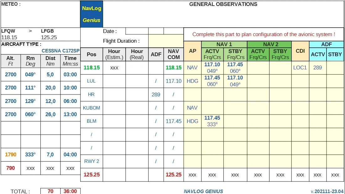
Sheet 2 : NAVLOG
I will not cover here the why and how of a navigation log but what you have to know (if not already known) is that a navigation log is a tool that you use to guide your preflight planning, and a plan that you execute in flight. The value you obtain from the navigation log is the centralization of all of the information you need in an easy to read, single location. Luckily the navigation log is pre-filled with the data that was encoded in the first sheet. This reduces the risk of encoding errors, and you only have to focus on the avionic system and specify its configuration at each step of your trip by specifying the following data once you reach a waypoint :
which auto-pilot mode (HDG, NAV, APR, …) must be set (if any)
Which active/stand-by frequencies for NAV1 and NAV2 must be set (if any)
Which CDI you will use (GPS, LOC1, LOC2)
which active/stand-by frequencies for ADF must be set (if any)
Like for the flight plan in the previous sheet, data in grey background should not be changed, they are computed from the flight plan. The cells you have to fill in are with light yellow background.
I hope this will be clear enough and easy to use. Do not hesitate to contact me in case of problems.
I will take the time to answer as soon as I have the time.
Thanks a lot already for your interest in this tool !


![[Ground Handling] TUI Textures v1.0](https://www.allflightmods.com/wp-content/uploads/2020/11/Ground-Handling-TUI-Textures-v1.0-520x245.jpg)
